


Reducing the risk of water-related disasters through technology and policy solutions
Advancement and Applications of Flood Forecasting
Phenomenon Explanation
We study how heavy rainfall in mountainous regions generates runoff into rivers through field observations and theoretical analysis. Specifically, we conduct drilling surveys in catchments with different geological settings to investigate the properties and spatial distribution of soils and weathered bedrock layers. Based on these data, we are developing new runoff models that directly incorporate laboratory-derived parameters. To validate the timing and location of surface flow predicted by distributed models, we also monitor surface runoff using trail cameras.
Technology Development
We develop and improve the Rainfall–Runoff–Inundation (RRI) model, which integrates rainfall–runoff processes with flood inundation analysis. The RRI model has been adopted by the Ministry of Land, Infrastructure, Transport and Tourism (MLIT) as well as by local governments such as Kyoto and Hyogo prefectures, serving as a core model for flood forecasting. We have applied the model nationwide at a resolution of 150 meters, enabling real-time flood forecasting for all rivers in Japan, including small and medium-sized ones. We are also advancing data assimilation techniques to incorporate observations and enhance forecasting accuracy.
Social Implementation
We transfer flood predictions into practical disaster risk reduction. For example, we support hospitals in creating emergency timelines using forecast information, optimize watershed storage facility operations under the Cabinet Office’s SIP “Smart Disaster Management” program, and ensure safety at river construction sites. Through these diverse applications, we contribute to more effective disaster mitigation in society.
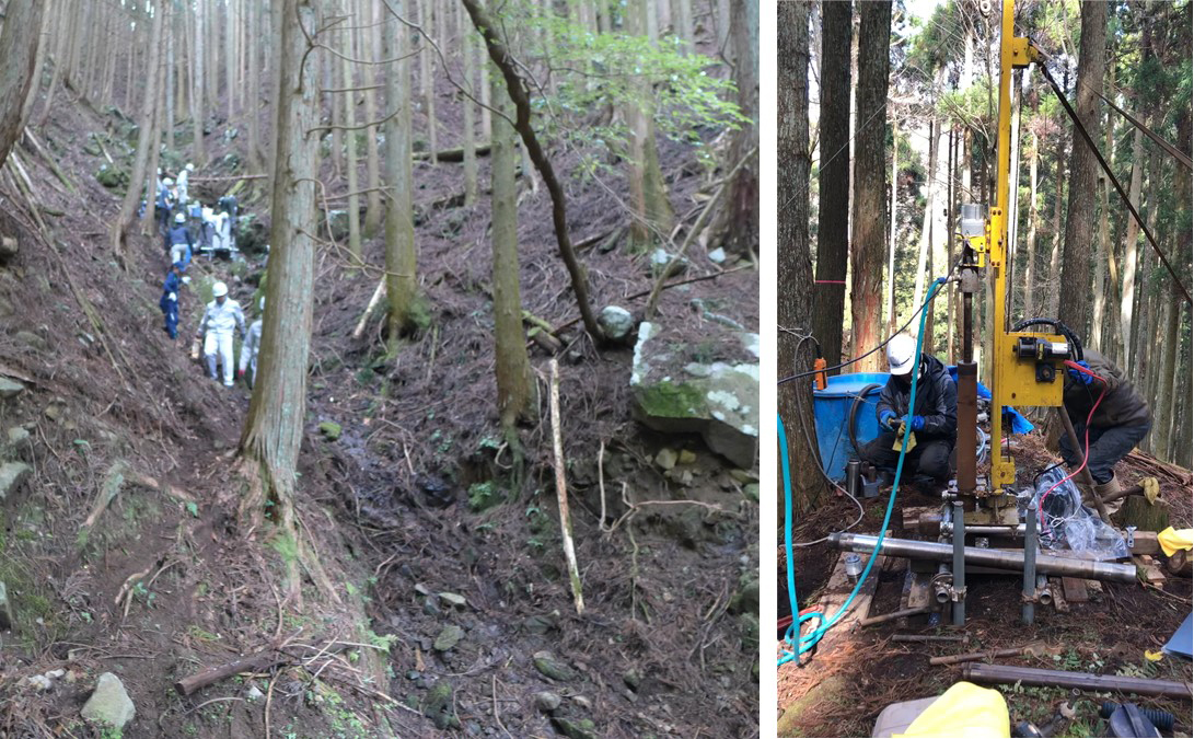
Field Survey for Understanding Rainfall-Runoff Processes
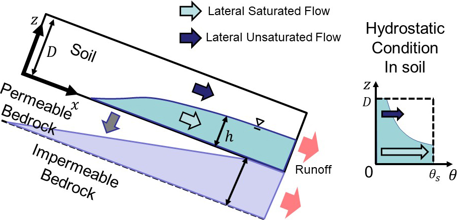
Development of a Rainfall-Runoff Model that directly incorporate laboratory-derived parameters
Y. Sugawara and T. Sayama: A new kinematic wave model that describes lateral subsurface flow and percolation in hillslopes,
Journal of Hydrology, Volume 631, 2024, https://doi.org/10.1016/j.jhydrol.2024.130726.
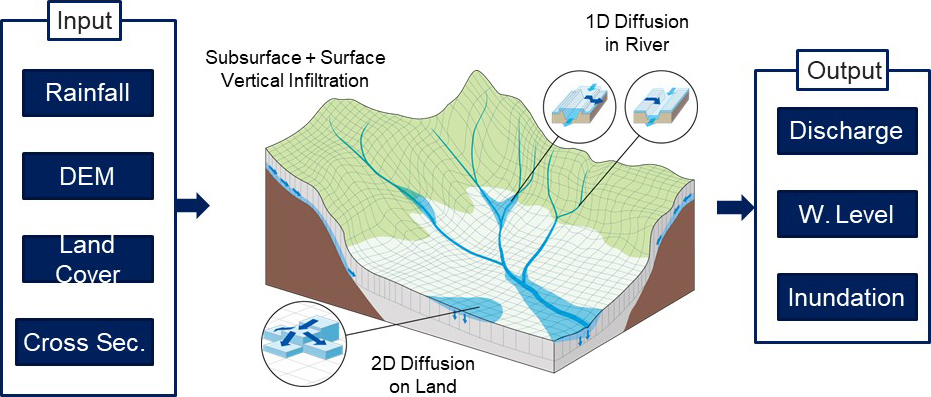
Development and Applications of the RRI (Rainfall-Runoff-Inundation) model
T. Sayama, G. Ozawa, T. Kawakami, S. Nabesaka, K. Fukami, Rainfall–runoff–inundation analysis of the 2010 Pakistan flood in the Kabul River basin, Hydrological Sciences Journal, 57:2, 298-312, 2012, doi:10.1080/02626667.2011.644245
T. Sayama, M. Yamada, A. Yamakita, A. et al. Parameter regionalization of large-scale distributed rainfall–runoff models using a conditional probability method. Prog Earth Planet Sci 12, 17 (2025). https://doi.org/10.1186/s40645-025-00691-w
Climate Change Impact Assessment
Technology Development
We study how climate change may alter the frequency and magnitude of water-related disasters in the future. To support this research, we develop methods for bias correction of climate data and multivariate extreme value analysis. Using these methods, we provide scientific evidence to assess whether complex events—such as simultaneous floods in multiple rivers or the compounding of floods and storm surges, which could occur more frequently under future climate conditions.
Future Predictions
We have developed methods to efficiently extract numerous heavy rainfall events from ensemble climate projections and use them as input to our nationwide RRI (Rainfall–Runoff–Inundation) model. This enables us to analyze the impacts of global warming on flood occurrence. Because this research requires an extremely large number of simulations, we make use of the “Earth Simulator” supercomputer.
Model Integration
Climate change raises concerns about compound disasters such as floods coinciding with storm surges, or floods occurring alongside droughts. To address these challenges, we participate in Japan’s advanced research programs funded by the Ministry of Education, Culture, Sports, Science and Technology (MEXT), collaborating with researchers within and outside our institute to develop an “integrated hazard model” that can account for multiple disaster drivers.
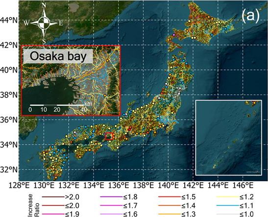
Assessment of Climate Change Impacts on Flood Runoff across Japan: Increase Ratios of 100-Year Flood Discharge under +2 Degree Warming Scenario
Chen, J., Sayama, T., Yamada, M., Tanaka, T., & Sugawara, Y. (2025). Projecting multiscale river flood changes across Japan at +2°C and +4°C climates. Earth’s Future, 13, e2024EF005884. https://doi.org/10.1029/2024EF005884
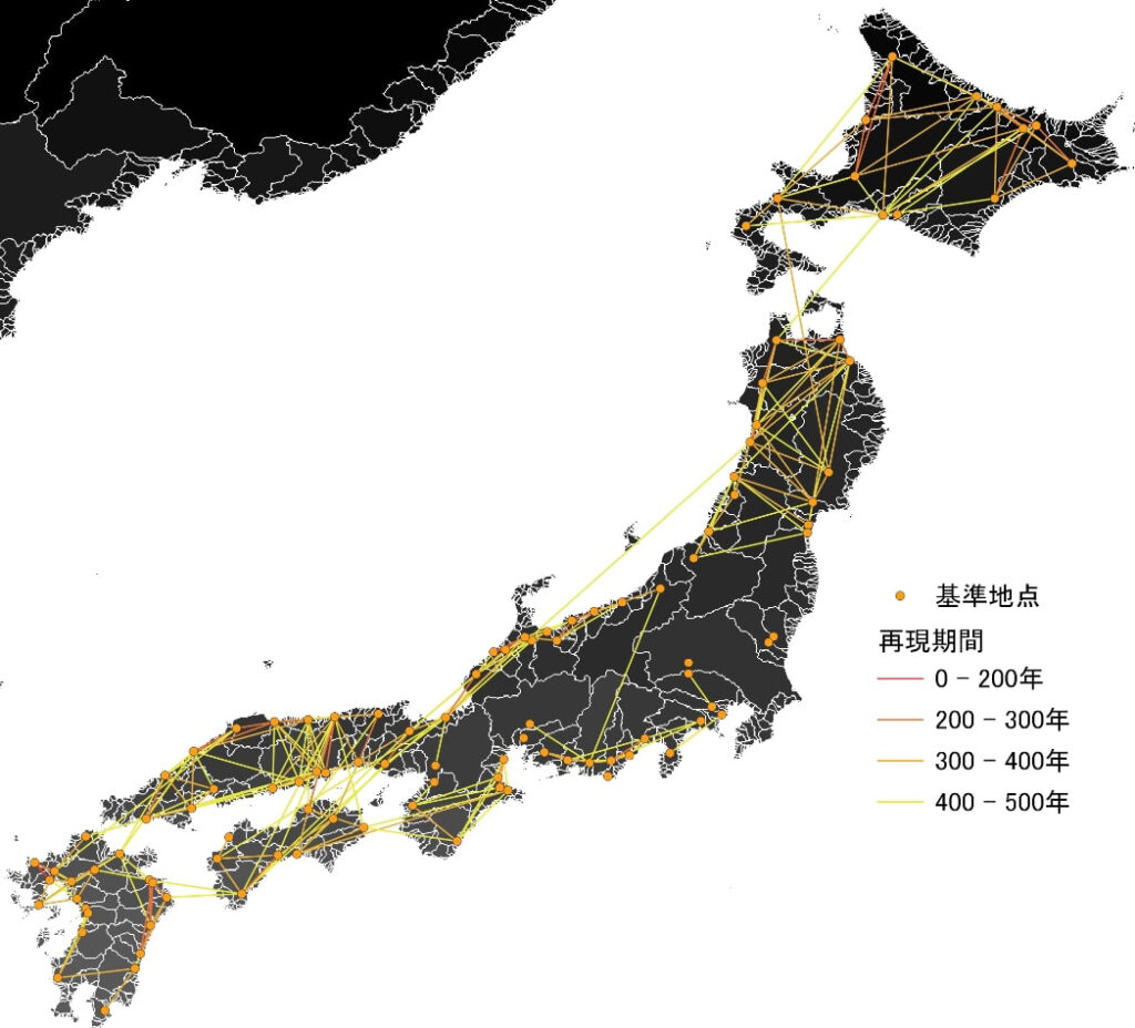
Return period of simultaneous occurrence of extreme floods (exceeding design scale) across all Class A river systems in Japan
Tanaka, T., Uchimura, S., Kitano, R., & Tachikawa, Y. (2024).Analysis of tail dependence between river flows in two river basins within a nationwide first-class river system using d4PDF and bivariate extreme value distribution. Journal of the Japan Society of Civil Engineers, 80(16), 23-16195.
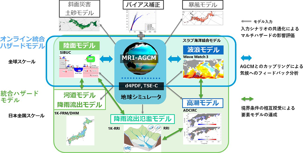
Development of Integrated Hazard Model (IHM) through MEXT Sentan Program
Water-Related Disasters and Society
Social Survey
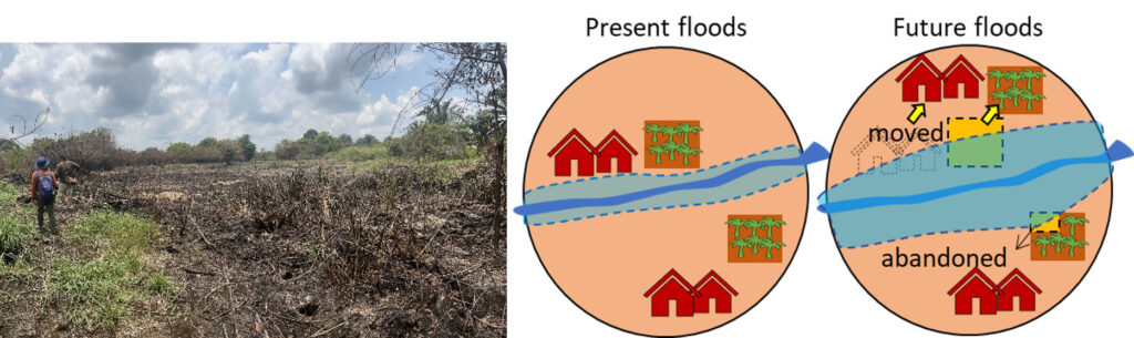
We investigate the interactions between water-related disasters and society through field surveys, questionnaires, and conceptual modeling of social structures. Case studies include the impact of rice crop flooding on income and inequality in rural Philippines; the links between oil palm cultivation, peatland fires, and floods in Sumatra, Indonesia; post-disaster redevelopment and gentrification issues in Brazil; and household decision-making regarding insurance purchase and residential relocation after flood damage.
Technology Development
Based on empirical surveys and conceptual models, we develop simulation techniques to predict social dynamics. For example, we use the CLUE (Conversion of Land Use and its Effects) model to project changes in land-use distribution, and agent-based economic and location choice models to simulate recovery dynamics after disasters. These models are also applied to policy scenario analysis, such as land-use regulations, relocation strategies, and financial measures.
Social Implementation
We share insights from social surveys and results from policy scenario analyses with governments, municipalities, and other stakeholders, contributing to evidence-based policy recommendations. At the same time, we refine our survey methods and modeling approaches based on feedback from stakeholders, ensuring continuous improvement and practical relevance.
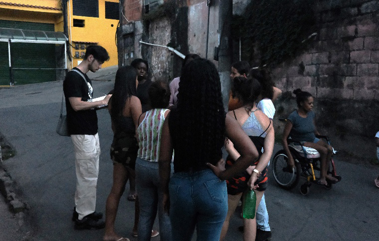
Field Interviews to Local Community in Brazil
Ohyama, A. C., Sayama, T., Lahournat, F.: Addressing vulnerability and social exclusion: insights from Brazil’s climate disaster context, The 2nd International Sociohydrology Conference, 2025.
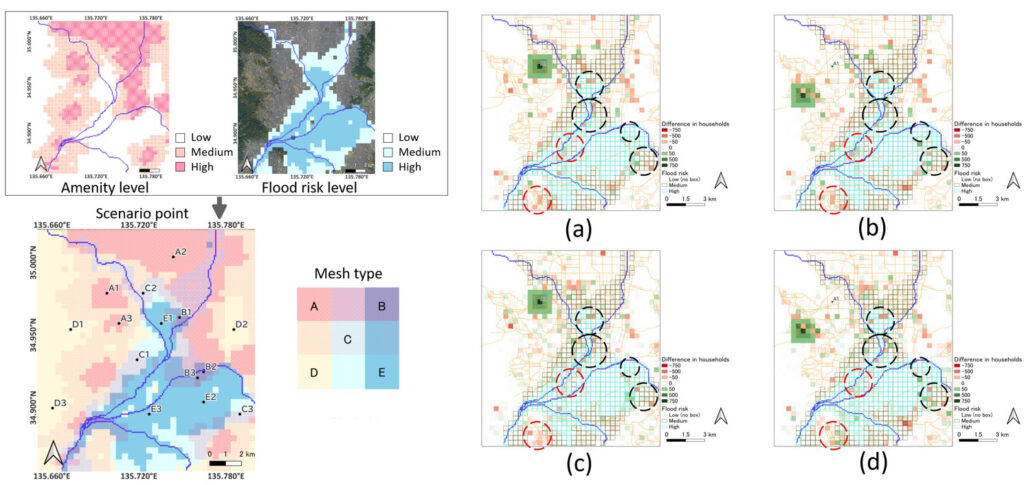
Projected Household Changes after 5 and 20 Years under Different Development Scenarios
Tanaka, T., Koga, A., Yokomatsu, M. (2024). Agent-based intra-regional relocation model considering spatial local amenity for urban planning-based flood risk management: Assessing the impact of urban development on flood exposure. Journal of Flood Risk Management,
e13035. https://doi.org/10.1111/jfr3.13035
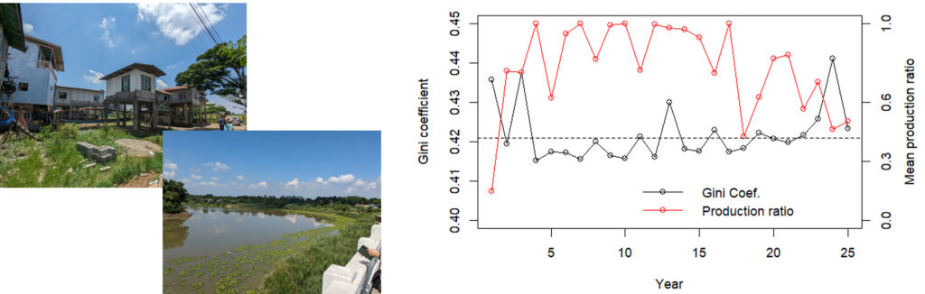
Comparison of Flood Inundation Scale (red line) , Gini coefficient values (dashed line) and the calculated values (solid line) in Rural Philippines (left diagram)
Tanaka, T. et al.: Socio-economic analysis of smallholder farmers under climate change in an agent-based approach: a case study in Candaba, the Republic of Philippines, The 2nd International Sociohydrology Conference, 2025.
Survey data on floods and fires in 2024 (left diagram) and Conceptual diagram illustrating the chain reaction of human activities, fires, and floods
Yamamoto, K., Yamamoto, E., Sayama, T., & Apip, A. (2021, December). Prediction of Future Land Use and Climate Change Impact Assessment on Flood Damage of Tropical Agriculture. In AGU Fall Meeting Abstracts (Vol. 2021, pp. H45Z-09).